Professional Drone Surveying Gold Coast
The Gold Coast is one of the fastest-growing regions in Australia, with constant demand for new development projects and infrastructure upgrades. To keep these projects on track, project managers and engineers need fast, accurate data. At SEQ Drone Inspections, we provide professional drone surveying Gold Coast services that deliver high-precision results in a fraction of the time required by traditional methods.
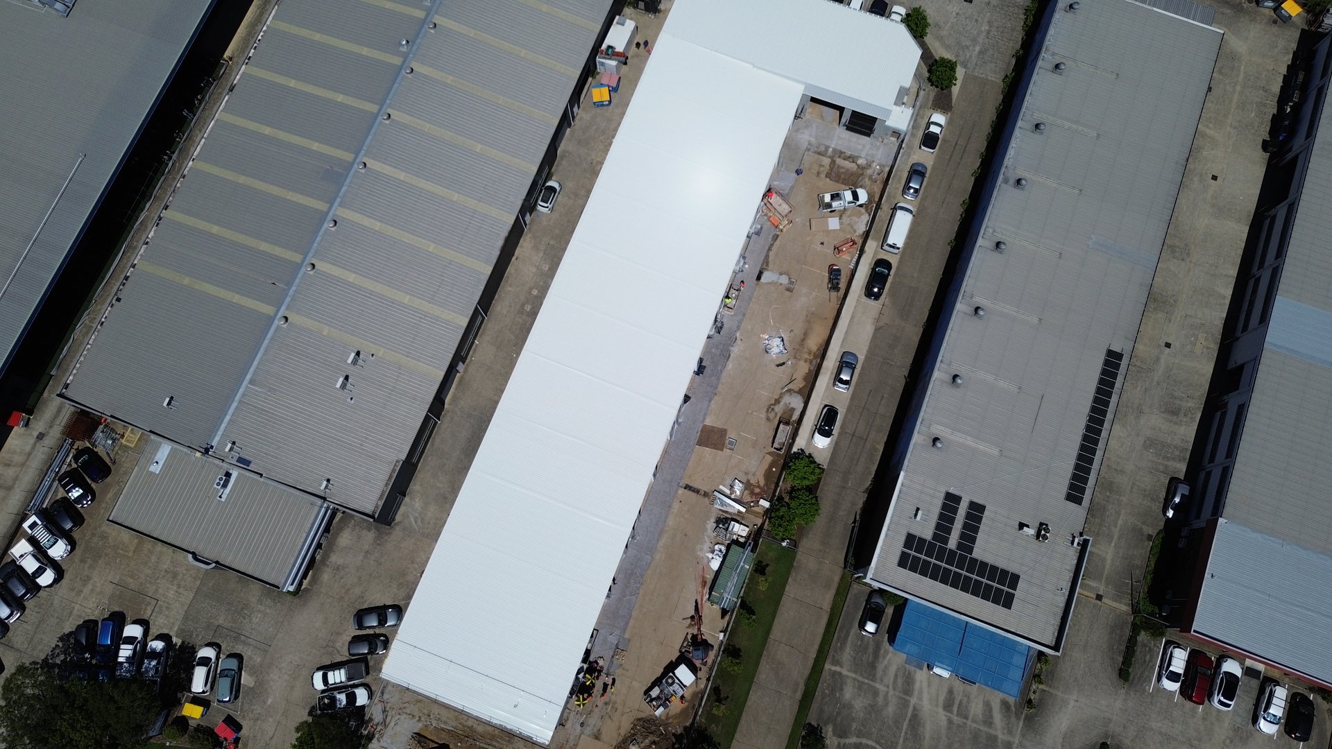
Our CASA-certified team uses advanced aerial drone technology to capture detailed accurate aerial mapping site data for Gold Coast construction and land development projects. Whether you are managing a large subdivision, a civil construction site, or a mining operation, our drone surveying solutions provide the insights you need to move your project forward. Explore our Gold Coast drone services or view surveying services.
What is Drone Surveying?
Drone surveying is the process of using unmanned aerial vehicles (drones) to capture aerial data with downward-facing sensors. This data is then processed using photogrammetry or laser scanning (LiDAR) software to create digital models of the terrain. Unlike standard aerial photography, aerial surveying produces geometrically corrected maps and 3D models that allow for precise measurements.
We specialise in transforming raw aerial imagery into actionable data. Our surveys are used for topographic mapping, volumetric calculations, and progress monitoring across South East Queensland. By integrating ground control points (GCPs) and high-accuracy GPS, we ensure that our digital models align perfectly with the real world, providing accuracy comparable to traditional land surveying.
The Advantages of Aerial Surveying
Choosing aerial surveying over manual ground methods offers significant benefits for your business.
Speed and Efficiency
Time is money on any construction site. Traditional land surveyors can take days or even weeks to measure large areas, especially in difficult terrain. Our drones can fly over the same site in hours, capturing millions of data points. This speed allows us to deliver the entire process—from flight to final report, much faster, ensuring you have up-to-date information when you need it.
Cost Effective Solutions
Deploying a full ground crew for weeks is expensive. Drone surveying is a cost effective alternative that reduces labor hours and equipment rental costs. Because we can cover large areas so quickly, we can offer affordable rates for comprehensive site surveys without compromising on quality.
Safety in Remote Areas
Surveying hazardous environments, such as quarries, steep slopes, or busy roads, puts staff at risk. Our aerial drone pilots operate from a safe location, keeping your team out of harm's way. We can access remote areas and dangerous zones easily, ensuring you get the data you need safely.
Our Drone Surveying Services
We offer a wide range of services tailored to the needs of the construction, engineering, and agricultural industries.
Topographic and Contour Mapping
We create detailed topographic maps that show the elevation and shape of the land. These surveys are essential for architects and engineers during the planning and design phase of development projects. Our contour mapping provides a clear view of the terrain, helping you optimize earthworks and drainage.
Volumetric Measurements
For mines, quarries, and construction sites, tracking stockpile inventory is critical. Our drones capture accurate volumetric measurements of stockpiles, cut and fill areas, and excavation pits. This allows you to monitor inventory levels and track earthmoving progress with high precision.
Construction Progress Monitoring
Keep your stakeholders informed with regular aerial surveys. We can fly your site at regular intervals to document the construction process. These surveys provide a visual and data-rich timeline of the job, helping you verify that work is proceeding according to the engineering plans.
3D Modelling and Digital Twins
We can generate high resolution 3D models of your site or assets. These digital twins allow you to virtually inspect the site from the comfort of your office. You can measure distances, areas, and heights directly on the model, improving collaboration among your team.
Why Choose SEQ Drone Inspections?
We are more than just drone operators; we are data specialists committed to delivering exceptional service.
Experienced Pilots
Our team has years of experience operating drones in complex environments. We understand the nuances of flight planning and data capture to ensure the best results.
Licensed and Insured
We operate under a CASA ReOC, ensuring all surveys are conducted legally and safely. We hold comprehensive insurance to protect our clients and the public.
High Accuracy
We understand that data is useless if it is not accurate. We use survey-grade equipment and ground control points to achieve high precision in all our mapping and surveying projects.
Local Expertise
Based in South East Queensland, we have local knowledge of the Gold Coast area and understand the specific challenges faced by local governments and developers.
Industries We Support
Our drone surveying capabilities extend across various sectors.
Civil Construction
Monitor earthworks, track site progress, and verify design adherence.
Mining and Aggregates
Calculate stockpile volumes and manage quarry operations efficiently.
Land Development
Assess land suitability and plan subdivisions with detailed aerial mapping.
Agriculture
Analyze crop health and terrain drainage to improve agricultural outcomes.
Environmental Management
Monitor erosion, vegetation growth, and land changes over time.
Gold Coast Development Data You Can Trust
Professional aerial surveying for coastal developments, infrastructure projects, and land management.
Delivering Accurate Data for Your Project
At SEQ Drone Inspections, our passion is helping you succeed. We understand that every project is unique, which is why we work closely with you to define the scope and required accuracy for your surveys. From the initial consultation to the final delivery of data, we form a partnership with our clients to ensure their specific needs are met.
We utilize a fleet of modern drones equipped with high-resolution cameras and sensors. This technology allows us to capture data with incredible detail, ensuring that even the smallest features are recorded. Whether you need a simple site plan or a complex 3D model, we have the tools and expertise to deliver.
Request Your Free Quote
Get a detailed quote for your Gold Coast drone surveying project. We respond within 24 hours.
Get Your Free Quote
24 hour turnaround on all quote requests